Berlin:
capital and chief urban centre of Germany. The city lies at the heart of the North German Plain, athwart an east-west commercial and geographic axis that helped make it the capital of the kingdom of Prussia and then, from 1871, of a unified Germany. Berlin’s former glory ended in 1945, but the city survived the destruction of World War II. It was rebuilt and came to show amazing economic and cultural growth.
Germany’s division after the war put Berlin entirely within the territory of the German Democratic Republic (GDR, or East Germany). The city itself echoed the national partition—East Berlin being the capital of East Germany and West Berlin a Land (state) of the Federal Republic of Germany (FRG, or West Germany). West Berlin’s isolation was later reinforced by the concrete barrier erected in 1961 and known as the Berlin Wall. Its status as an enclave made Berlin a continuous focus of confrontation between the Eastern and Western powers as well as a symbol of Western lifestyle for 45 years. The fall of the East German communist regime—and the accompanying opening of the wall—in late 1989 unexpectedly raised the prospect for Berlin’s reinstatement as the all-German capital. That status was restored in 1990 under the terms of the unification treaty, and subsequently Berlin was designated a state, one of the 16 constituting Germany. These developments heralded the city’s return to its historic position of prominence in European culture and commerce. Area 344 square miles (891 square km). Pop. (2011) 3,292,365; (2021 est.) 3,677,472.
The city layout in Berlin in Physical and human geography
The original twin towns of Berlin and Kölln developed from the early 13th century onward, on an island of the Spree River (the site of Kölln) and a small portion of land on the north bank of the river facing the island (the site of Berlin). While still a small town, it became the capital of the electoral princes of Brandenburg from the end of the 15th century onward. From the late 17th and early 18th centuries, when the electors of Brandenburg (also kings of Prussia from 1701) developed into powerful figures on the European political stage, the city expanded and gained a Baroque appearance; new castles, such as Char lotten burg Palace, were built. The central quarter expanded and was embellished with broad avenues, handsome squares, and grandiose stone buildings. The central area acquired broad north-south avenues, such as Wilhelmstrasse and Friedrich strasse, and also its characteristic east-west road axis. Supplementing this main axis are several exit roads that now serve as major traffic arteries. In the late 19th century suburbs developed around these arteries and their subsidiary streets. Where destruction during world war II was massive, there has been large-scale construction of modern apartment and office buildings, one of the most famous being the Hansa Quarter, built by renowned architects from many countries.
climate
Berlin is located where the continental plain’s climate starts to take over and the Atlantic Ocean’s impact diminishes. The average yearly temperature in the city is around 48 °F (9 °C), with winter temperatures ranging from 30 °F (−1 °C) to summer temperatures of 65 °F (18 °C). 22 inches (568 mm) of precipitation falls on average. Snow makes up between one-fifth and one-fourth of the total.
The Brandenburg Gate, Berlin
King Frederick William II is responsible for the Brandenburg Gate, which was commissioned as a stately end to the majestic Unter den Linden avenue. Many people agree that the gate is one of the most exquisite examples of a classical structure. Designed by Carl Gotthard Langhans the Elder, who was greatly influenced by the Propylaea of the Athenian Acropolis, it was constructed between 1788 and 1791. A chariot propelled by four horses, known as the Quadriga, was positioned on the roof of the Brandenburg Gate two years after it was finished.
The Quadriga on Top of the Brandenburg Gate
The Quadriga was placed on top of the Brandenburg Gate by Johann Gottfried Schadow in 1793. The sculpture, depicting a two-wheeled chariot pulled by four horses running side by side, was meant to symbolize peace entering the city. The horses’ reins are held by Victoria, the goddess of victory. Over the course of time, the sculpture was taken down from the Brandenburg Gate a total of three times. After the defeat of Prussia in 1806, Napoleon took the Quadriga to Paris. However, the victory of the Alliance allowed it to be brought back and put back in its old place eight years later. During the Second World War, the Brandenburg Gate and the Quadriga were severely damaged by bombing. The sculpture therefore had to be disposed of in 1956 in the course of the reconstruction of the gate and replaced by a copy.
Restoration of the Brandenburg Gate
Damage to the sandstone’s substance is unavoidable because the Brandenburg Gate is situated directly in the middle of the city. The building also sustained long-term damage from the yearly New Year’s Eve fireworks above the gate. Thus, on October 3, 2002, the Brandenburg Gate was ceremoniously reopened following nearly two years of renovation. Since then, it has drawn tourists from all over the world once more.
Around the Brandenburg Gate:Pariser Platz
One of the most exquisite squares in Berlin is Pariser Platz (“Parisian Square”), where the Brandenburg Gate is situated. The area is easily accessible from the majestic street Unter den Linden and is dotted with several notable structures, including the US Embassy, the University of the Arts, and the opulent hotel Adlon Kempinski. The nearby eateries and cafés entice guests to linger and enjoy the unique atmosphere.
Map


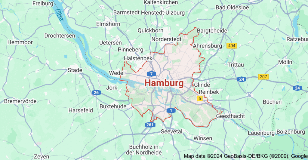
Hamburg
The city and land (state), Location on the Elbe River in northern Germany. Its is the country’s largest port and commercial centre.
Hamburg’s official name, which encompasses both the Land and the town, reflects Hamburg’s long tradition of particularism and self-government. Hamburg and Bremen (the smallest of the Länder) are actually the only German city-states that retain some of their medieval independence. Hamburg is the most populous city in Germany after Berlin, and it has one of the biggest and busiest ports in Europe. Hamburg is the second smallest of the 16 Länder of Germany, covering only 292 square miles (755 square km). Hamburgers are proud of their own individualism, which has allowed the city’s culture to remain distinctive in many areas of both public and private life and to resist the overall tendency toward uniformity. Despite having a relatively small number of foreign residents, Hamburg is a cosmopolitan city in its outlook; it has more consulates than any other city in the world, with the exception of New York City; shipping and trade have been the city’s main drivers for centuries; and it is not surprising that its harbor continues to be its most significant feature. having undergone suffering significant damage during World War II, Hamburg continues to manage to preserve its old-world sophistication alongside its thriving commercial life. Area 292 square miles (756 square km); Pop. (2011) 1,706,696; (2021 est.) 1,853,935. Other attractions that have contributed to a growing tourist industry encompass a network of canals reminiscent of Amsterdam; lakes, parks, and verdant neighborhoods full of gracious houses; elegant shopping arcades; richly endowed museums; or a vibrant cultural life.
The city layout
Aside from the five main churches—Sankt Jacobi, Sankt Petri, Sankt Katharinen, Sankt Nikolai, and Sankt Michaelis—all of which are in poor condition, the city’s core is the Altstadt (Old Town), a former medieval settlement that is surrounded by the harbor and a network of roads that trace the line of the old fortifications. Nearly all of the older homes and warehouses have been destroyed by fire, and what has been rebuilt for modern uses. There are, nevertheless, a few isolated survivals of earlier structures. Moreover, the layout of the old city core may still be identified in some of the older street names and in the Fleete (canals), which connect the Alster with the ports on the Elbe. The Lombardsbrücke (Lombard Bridge) offers one of the nicest views of the inner city, with the five churches’ towers towering high against a cityscape that is still mostly harmonious despite the presence of contemporary buildings.
situated in the center of Hamburg is a 455-acre (184-hectare) lake that was created by damming the Alster and subsequently separated from the Binnenalster (Inner Alster) by the Lombardsbrücke. The Aussenalster (Outer Alster) is surrounded by upscale suburbs like Rotherbaum, Harvesterhude, and Uhlenhorst, and it has numerous waterways that are visible by pleasure boats.
Architecture
The Deichstrasse, which backs into the Nikolai canal on one side, is home to the last surviving example of old Hamburg architecture. Originally constructed between the 17th and the 19th centuries, its towering, thin homes resemble those of Amsterdam. The terrible fire of 1842 started in one of them, number 42, which is today a restaurant. The homes were then reconstructed in the traditional manner. The roadway has been extensively restored in recent years and is now a protected area. It has a lot of classic eateries.
The Krameramtswohnungen, next to Sankt Michaelis, are another example of earlier building that has survived. It was constructed as a set of residences for shopkeepers’ widows and is the sole example of a 17th-century structure of its type still standing in the city. It consists of two half-timbered brick houses on either side of a small courtyard. After undergoing extensive restoration in 1971 and 1974, it now forms a charming, quiet lane with a café, modest stores, and a Museum für Hamburgische Geschichte (Museum of Hamburg History) branch.
Climate of Hamburg
Hambung experiences high humidity, frequent fog, moderate winter, late springs, and comparatively cool summers with an average winter temperature of 34.2 °F (1.2 °C) and a summer temperature of 62.4 °F (16.9 °C)
The people
The population is primarily Roman Catholic, with over three-fourths of the total population being Protestant; there is a small Muslim community, which includes many Turkish Gastarbeiter (guest workers); and the Jews, who was comprised of 27,000 in 1933 (the year Hitler came to power), now number only about 1,000.
Transportation
Hamburg’s harbor serves as its “gateway to the world.” Every year, more than 15,000 ships from more than 100 nations go through it. The Waltershof container terminal is the biggest of its kind on the continent, and the city’s Übersee-Zentrum is the biggest covered warehouse in the world.
The city has a robust bus and underground train system, and the German railway network serves the city and harbor efficiently. As part of the Stockholm-Lisbon expressway, a tunnel was constructed beneath the Elbe to relieve long-distance traffic in the core city. The tunnel opened in 1977. One of the older airport in Europe in Hamburg–Fuhlsbuttel, which opened in 1911. Even the biggest jet-powered aircraft can take off from its tow runways.
Government
The constitution of June 6, 1952, states that the Legislative authority is vested in the Bürgerschaft (State Parliament), which consists of 120 members elected to four-year terms; the Senat, which is organized on a collegiate basis, elects the government; the president, or erster Bürgermeister (“first mayor”), is chosen by the Senat itself each year, though in reality, each incumbent typically serves for at least four years; the Senat as a whole represents the Free and Hanseatic City of Hamburg in its interactions with the other federal Länder, the federal government, and foreign states; each senator is in charge of a specific department, but local administrative issues are left to the district offices and local authorities.
Located in the city center, next to the Binnenalster, the beautiful Rathaus (City Hall), where the Senat and the Bürgerschaft convene, was constructed in the Neo-Renaissance style at the end of the 1800s.
The three-towered castle on Hamburg’s coat of arms is meant to symbolize the city. It is silver (argent) on a crimson (gules) background, and its design is based on the city’s famous seal from 1241. A white castle on a crimson background is also seen on the state flag. G.N. Bärmann composed the state’s hymn, “Stadt Hamburg a der Elbe Auen” (literally, “City of Hamburg by the Meadows of the Elbe”), in 1828, and Albert Methfessel composed the music.
Education
Founded in 1919, the Universität Hamburg is one of the biggest educational institutions in Germany, with 46,000 students and faculty members that teach almost every topic except technology. Classes at the Technische Universität Hamburg-Harburg, a second university, started in 1982. Along with around 250 research centers in fields including hydrography, oceanography, tropical medicine, shipbuilding, economics, meteorology, and particle acceleration, Hamburg also has state schools for music, interpretive art, and the art of sculpture.
Map

Cologne
History of cologne
Following the destruction of the Eburones by Julius Caesar in 53 bce, the Roman general Agrippa settled the region with a different tribe known as the Ubii, who arrived from the right bank of the Rhine. Around 38 bce, Julia Agrippina, the wife of Claudius, was born here, and it was at her request that the town was given the title of Roman colony in 50 bce. Later, it was designated as the headquarters of the governor of Lower Germany, and after 258 CE, it briefly served as the capital of a splinter empire ruled by Postumus that included Gaul, Britain, and Spain. Constantine the Great constructed a castle and a permanent bridge to it across the Rhine in 310. Cologne was known for its glass and ceramics during the Roman era. It was overrun by the Franks in 456 and quickly became the home of the kings of the Ripuarian region of the Frankish kingdom. A Christian community was present in Cologne as early as the second century, and it was first recorded as a bishopric in 313; in the late 8th century, Charlemagne turned it into an archbishopric, and by the 10th century, the archbishop controlled the city and received a variety of tolls, customs duties, and other payments. During the Middle Ages, the city’s trade and industry expanded, particularly starting about the 10th century, and a growing number of acrimonious disputes arose between the archbishop and the wealthy merchants. While the latter strove to maintain his temporal power, which was enhanced in the 13th century when the archbishop was granted the prerogative of choosing the German king, the former desired political and commercial independence. The city of Cologne did not achieve complete self-government until the archbishop was ultimately overthrown in the Battle of Worringen in 1288. Although it wasn’t formally acknowledged as such until 1475, Cologne was actually a free imperial city from that point on.
The wealthy patricians controlled the city’s government until the end of the 14th century. However, following a bloodless revolution in 1396, a new municipal constitution was established, establishing the 22 branches of the guilds as the foundation of the government. This was because they elected a council that had authority over all matters both inside and outside the city.
For Cologne, this medieval era was magnificent. Of all the German towns, its merchants likely had the widest networks and the most diverse commerce, and it was a major player in the mercantile Hanseatic League. Crafts included metalworking, leatherworking, enameling, bookmaking, and textile production; Cologne’s goldsmiths produced especially exquisite pieces. There, religion and the arts also thrived.
The schools of Cologne were home to three of the finest Roman Catholic academics and theologians of medieval Scholasticism: John Duns Scotus, Thomas Aquinas, and Albertus Magnus. However, the city collapsed after the Thirty Years’ War (1618–48). The city has remained largely Roman Catholic, and public Protestant services were still prohibited as late as 1794, when the French took over Cologne. Jews have lived in the city since the reign of Constantine the Great, but they were exiled in 1424, and they were not allowed to stay overnight until 1794.
Landscape
City site
Cologne is a business located around 25 miles (40 km) southeast of Düsseldorf and 21 miles (34 km) northwest of Bonn. Situated immediately below the point where the Rhine meets the rich North German Plain, it is 210 feet (65 meters) above sea level. At this point, seagoing boats may navigate the river. Cologne’s near surroundings are diverse. The gorgeous Bergisches Land hills are located to the east, while the Ville, another range of hills, is located to the west. The Rhine Valley runs southeast into Bonn, while the North German Plain extends north and northwest. The longest distance across the city from west to east is around 17 miles (27 km) and from north to south about the same. There are 85 districts, split into nine Bezirke (city regions). In addition to a collection of suburbs on the right bank of the river, some of which were annexed in 1975, the majority of the city is located on the left (west) bank. The area has a humid yet moderate environment. January temperatures in the Cologne region average 36 °F (2 °C), while July temperatures average 64 °F (18 °C).
City layout
A defensive wall that was finished about 1200 and was 4 miles (6 km) in length initially gave the Inner City its semicircular shape. The wall provided safety for between 35,000 and 40,000 people and encompassed a number of once distinct parishes. (Cologne was larger than Paris at the time.) The Rhine created the semicircle’s flat side. The medieval defenses were destroyed in the 1880s, and the Ringstrassen, a system of ring roadways, took their place. Even though Cologne has expanded much beyond the Ringstrassen, the Inner City remains the city’s central location. There are the city’s ancient buildings and the main commercial and retail streets, such the Hohe Strasse (north-south) and Schildergasse (west-east), which are both restricted to cars. At Cologne, a number of bridges cross the river; five of them were restored following World War II, while the others were added after the war.
Parkland, forests, lakes, sports facilities, and open spaces make up a sizable amount of Cologne’s land area. The circular patterns of the historic defenses surrounding the Innenstadt are generally followed by two major park systems. The first is located just outside the Ringstrassen and consists of the Stadtgarten, the Volksgarten, and botanical and zoological gardens (from north to south). The second is the Outer Greenbelt, a mile-long, forested area that encircles the city’s western and southern borders and is home to the Müngersdorfer Stadium and numerous recreational facilities. On the right bank of the river is the Rhine Park, a large green area adjacent to the KölnMesse, a convention centre with halls for fairs and exhibitions. Also located on the right bank is a covered multiuse arena offering space for sporting events and musical concerts.
People
The only bigger cities in Germany are Berlin, Hamburg, and Munich; Cologne is the fourth biggest. About four out of five of its residents are German, while the majority of the rest are guest workers from southern Europe who have been in the city since the 1970s, mostly from Turkey and Italy but also from the Balkan republics. Though there is a sizable Protestant minority, Roman Catholicism is the most common religion in Germany. A tiny Jewish community and a large Muslim group are also present.
Education
The city is home to colleges for the study of music, engineering, administration, and other professions and trades, as well as teacher-training colleges and a school of sports. The University of Cologne was established in 1388, dissolved in 1798 (during the French occupation of the city), and refounded in 1919.
Transportation
Cologne has become a communications hub due to its strategic location and economic significance. The city is the busiest rail intersection in the nation and a key hub for the developing high-speed passenger rail network in Germany and Europe. The city is surrounded by a perimeter road from which autobahns stretch forth. An international airport that serves as a hub for aviation freight and provides international passenger service is situated halfway between Cologne and Bon.
One of Germany‘s bigger inland ports is the Rhine harbor, which has been significant since the Roman era. There are a number of ship lines offering Rhine tourism, and the river is used by small oceangoing ships. Intracity transit consists of streetcars, buses, and a subway system.
Map


Let’s see how far we can take this tonight – https://rb.gy/es66fc?clelay
Can you guess what I’m craving right now? – https://rb.gy/es66fc?clelay
“I sense we have plenty in common. Drop by https://rb.gy/44z0k7?clelay ?”